Why Is the Black Desert in Egypt Black? Geology Explained
Last reviewed: 7 September 2026
Why is the Black Desert in Egypt black? The short answer is that several geological features overlap: dark igneous rock caps some hills, iron-rich sedimentary rocks occur across the Bahariya region, and erosion has spread dark fragments and gravel over lighter ground. Together, these materials create the Black Desert's black, charcoal, brown, and rust-colored appearance.
It is not one continuous field of black sand. It is also inaccurate to describe every conical hill as a volcano. The landscape is more interesting than either simplification: old sedimentary layers, iron minerals, later igneous activity, faulting, weathering, and erosion all contributed to what visitors see today.
Direct answer: Egypt's Black Desert looks black mainly because many of its hills carry dark basaltic caps or intrusions, while iron-rich rocks and weathered dark fragments cover parts of the slopes and desert floor. The exact mix varies from one hill and outcrop to another.
The Black Desert at a glance
The clearest scientific description comes from a peer-reviewed study of the geological heritage of the Bahariya and Farafra oases. It identifies ferruginous sandstone and shale of the Bahariya Formation at the depression floor, describes black conical hills, mesas, and buttes, and notes that most of the black hills are capped by basalt sills. The study also records sheets of black gravel and rock fragments across the surface. That combination is the basis of the explanation below.
Where is Egypt's Black Desert?
The Black Desert lies in Egypt's Western Desert, south of the main settlements of Bahariya Oasis and north of the White Desert. Bawiti is the practical gateway for most visitors. NASA's Earth Observatory places Bahariya roughly 380 kilometers southwest of Cairo, while Egypt's official tourism portal describes Bahariya as the closest Western Desert oasis to Cairo and a base for excursions to both the Black and White Deserts.
The name “Black Desert” generally refers to a broad landscape rather than a fenced attraction with one universally agreed entrance. On an overland itinerary, the transition becomes visible as dark hills and gravel-strewn surfaces rise from a much paler desert background. Exact stops depend on the route, ground conditions, permissions, and the guide's plan.
For journey planning, read how to get to Bahariya Oasis from Cairo and the practical Black Desert Egypt travel guide. Those pages answer transport and visitor questions; this article concentrates on why the landscape looks the way it does.
What does “black” mean here?
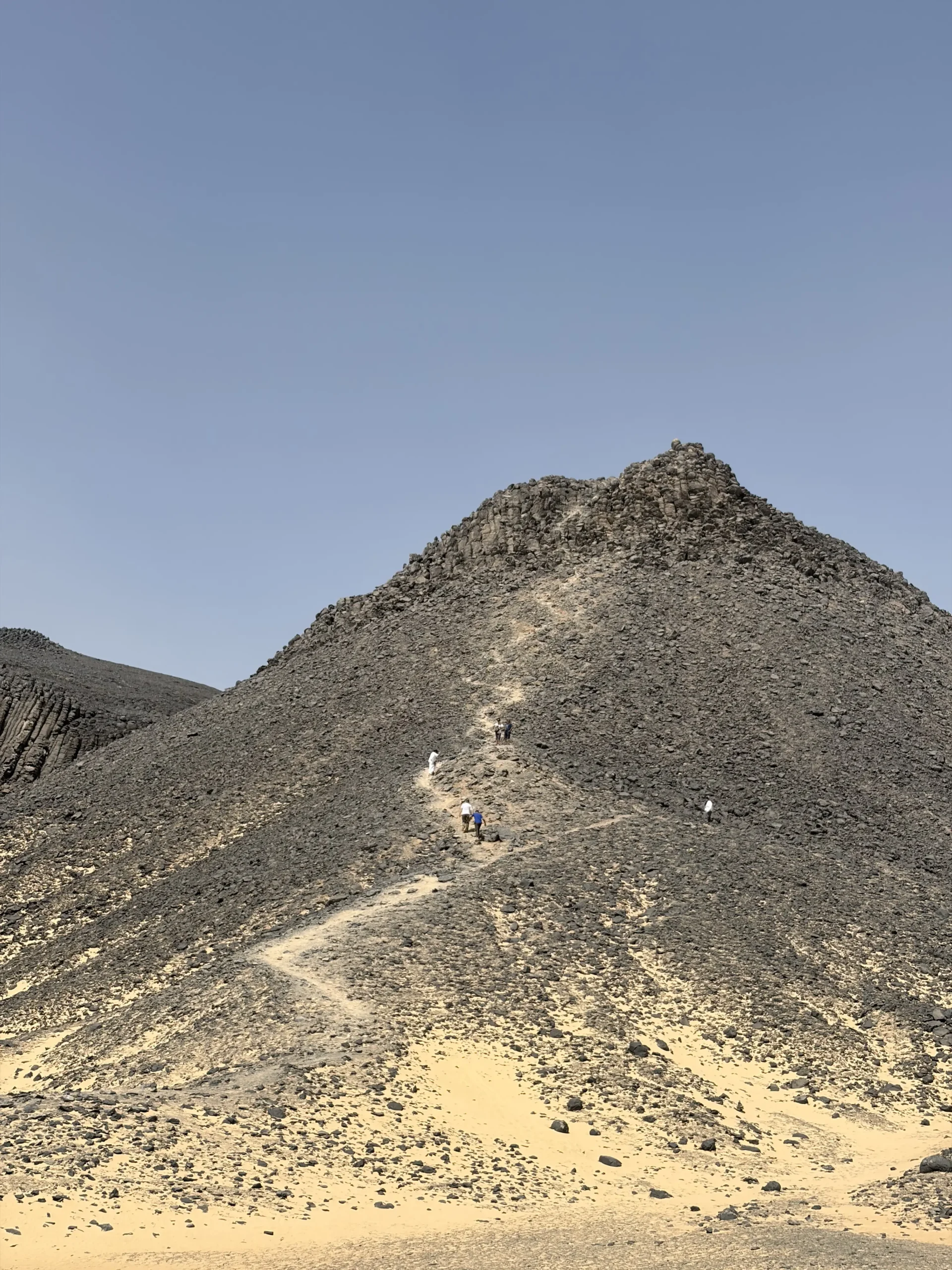
The word can create the wrong mental image. Much of the Black Desert is not jet black. Depending on the location, light, and weathered surface, the same view may contain:
- Charcoal-gray rock caps
- Dark brown gravel
- Rust-red or ochre iron staining
- Pale sandstone or dusty beige sediment
- Black fragments scattered across lighter slopes
- Shadowed hill faces that appear darker at sunrise or late afternoon
This color range matters geologically. Basaltic rock is commonly dark because it contains abundant mafic minerals. Iron-bearing sedimentary rocks can weather into brown, red, yellow, or nearly black surfaces depending on mineralogy, oxidation state, grain size, coatings, moisture, and lighting. A photograph cannot by itself identify the mineral or origin of every dark patch.
The Black Desert is therefore best understood as a high-contrast geological landscape, not a monochrome one.
The five-part geological explanation
A useful way to understand the Black Desert is to separate five connected processes:
- Sediment accumulated: Sand, silt, and mud were deposited in environments that existed during the Cretaceous Period.
- Iron became concentrated: Iron-bearing minerals formed or accumulated in parts of the sedimentary succession through more than one geological process.
- Magma entered the rocks: Later igneous activity produced dark basaltic and doleritic bodies, including sheet-like intrusions.
- The region was fractured and reshaped: Faulting, uplift, and long-term erosion exposed different rock units.
- Weathering spread dark fragments: Resistant dark rocks broke down into gravel that now covers or dots parts of the surface.
No single step explains every hill. The visible landscape is the combined result.
The sedimentary foundation: the Bahariya Formation
The lower parts of the Bahariya Depression expose rocks of the Bahariya Formation. Geologists place this formation in the Cenomanian age of the Late Cretaceous. In plain language, its sediment was deposited tens of millions of years before the modern desert landscape existed.
The formation includes sandstone, siltstone, mudstone, and shale, and many of these rocks are ferruginous—meaning that they contain or are cemented by iron-bearing material. Studies of the formation describe changing river, delta, coastal, estuarine, lagoonal, and shallow-marine settings. That does not mean every Black Desert stop represents every environment. It means the wider sedimentary succession records a varied ancient landscape in which sand and mud were repeatedly deposited.
These relatively softer sedimentary layers form much of the foundation beneath the darker resistant rock. When erosion cuts into them, it can leave isolated hills, flat-topped remnants, and steep-sided forms.
Why sedimentary layers matter to the color
Iron-bearing cement, nodules, crusts, and bands occur within parts of Bahariya's sedimentary record. Their weathered surfaces can add dark brown, rusty, reddish, or ochre tones. At the same time, pale sand and weathered shale remain visible between dark fragments. This is why a Black Desert hill often shows several colors in one profile rather than a single black rock from base to summit.
The region's famous iron deposits are geologically important, but they should not be used as a catch-all explanation. Research distinguishes ironstones in Cretaceous clastic rocks from ironstones associated with younger Eocene carbonate rocks. Their mineral assemblages and histories are not identical. The black hills that visitors photograph cannot simply be described as exposed iron ore mines.
The iron story: goethite, hematite, siderite, and more
Peer-reviewed studies of the Bahariya region identify iron-bearing minerals including goethite, hematite, and siderite; some locations also contain iron-rich carbonates such as ankerite or ferroan dolomite, as well as manganese oxides. These names are useful only if we avoid turning them into an oversimplified color chart.
- Hematite commonly produces red to reddish-brown tones, although its appearance varies.
- Goethite is frequently yellow-brown, ochre, dark brown, or nearly black in massive material.
- Siderite is an iron carbonate that can alter during weathering and contribute to later iron oxides and hydroxides.
- Manganese oxides, where present, can form very dark coatings or bands.
This is why the sentence “the desert is black because it contains iron” is incomplete. Iron is important, but different iron minerals produce different colors, and the most conspicuous dark caps on many hills are linked to mafic igneous rocks.
Did the iron form in one event?
Available research says no. A study comparing Bahariya ironstones found that occurrences in Cretaceous clastic rocks and Eocene carbonate successions have different geochemical signatures and geological constraints. Another study interprets certain ironstone crusts in the lower Bahariya Formation as late-diagenetic products—materials formed or modified after sediment deposition while the sediment was becoming rock.
Elsewhere in the oasis, researchers have debated sedimentary, diagenetic, replacement, and hydrothermal contributions to iron mineralization. For a traveler, the important conclusion is simple: Bahariya's iron geology has more than one chapter. It is not accurate to assign every dark stone to a single ore-forming event.
Basalt and dolerite: the darkest rocks in the landscape
Basaltic and related mafic igneous rocks are central to the Black Desert's appearance. “Mafic” describes rocks relatively rich in magnesium- and iron-bearing minerals. These rocks are generally darker than quartz-rich sandstone or white chalk.
Published work in Bahariya has described basalt, dolerite, olivine-bearing basaltic rocks, and shallow intrusions. Rock names can vary with texture, mineral proportions, and the scale at which the body cooled. Basalt usually has a fine-grained texture because it cools relatively quickly; dolerite, also called diabase in some naming systems, is compositionally related but typically has a coarser texture produced by slower cooling in a shallow intrusion.
For a visitor, both may look simply dark gray or black. A proper identification requires a fresh surface, texture, mineral examination, and geological context—not only a phone photo.
What is a basalt sill?
A sill is a sheet-like body of igneous rock that intruded between older rock layers, broadly parallel to their bedding. The U.S. Geological Survey definition of a sill emphasizes this tabular, layer-parallel geometry.
Imagine sedimentary layers as pages in a closed book. If magma forces its way between two pages and cools there, the resulting sheet is a sill. If magma cuts sharply across the pages, geologists would normally call that cross-cutting body a dike.
This distinction prevents a common mistake. A dark cap on a hill is not automatically the remnant of a lava flow poured over the ancient ground surface. At least some of Bahariya's dark bodies are intrusive sills that solidified within a pre-existing sedimentary sequence and were exposed only after erosion removed overlying rock.
Why a sill can become a hill cap
Mafic igneous rock is often more resistant to erosion than the softer sandstone or shale beneath it. Once erosion exposes a sill, the hard sheet can protect the underlying layers like a roof. The surrounding unprotected sediment wears away faster, leaving a capped hill, mesa, or butte.
This relationship explains why a dark rock layer may sit high in today's landscape even though it originally intruded underground. Elevation does not prove that the rock erupted at the top of a volcano.
Are the Black Desert hills extinct volcanoes?
Some travel descriptions call every conical hill a “volcano.” That wording is too broad.
There is real evidence of igneous and hydrothermal activity in the Bahariya region. Geological studies document basaltic rocks, shallow intrusions, faults, and later episodes of magma movement. A Frontiers in Earth Science study links structures in the Western Desert to fault-controlled magma ascent and hydrothermal venting. Older field studies also described multiple volcanic and intrusive rock types in Bahariya.
However, three facts require caution:
- A cone-shaped landform can be produced by differential erosion.
- Many Black Desert hills include sedimentary layers capped by resistant igneous rock.
- An intrusive sill is not the same feature as a volcanic cone built from erupted lava, ash, or scoria.
The most defensible answer is that the wider region has genuine igneous and volcanic history, while individual Black Desert hills must be interpreted from their rock relationships. Some locations may preserve volcanic or vent-related features; many familiar dark hills are erosional remnants of layered rocks capped by basaltic material. Shape alone is not enough to classify one.
If a tour description uses the phrase “volcanic hills,” treat it as a broad visual label unless a specific outcrop has been mapped and identified by geologists.
Differential erosion: how the hills took shape
Differential erosion occurs when rocks of different hardness or resistance wear away at different rates. Wind, occasional rainfall, temperature changes, salt growth, gravity, and surface runoff all contribute in an arid environment.
In the Black Desert, the process can be summarized as follows:
- Dark, resistant igneous rock or iron-cemented material overlies softer sediment.
- Cracks allow physical and chemical weathering to attack the rocks.
- Softer sandstone and shale are removed more quickly.
- The resistant layer temporarily protects the material directly below it.
- An isolated hill, flat-topped mesa, or smaller butte remains.
- The cap eventually fractures and sheds blocks and gravel down the slopes.
Over long periods, even the resistant cap retreats. A broad sheet can become separate remnants; a mesa can narrow into a butte; a butte can shrink into a low mound surrounded by its own debris.
This is not a static museum display. The processes are slow on a human timescale, but the ground is still responding to heat, wind, gravity, and rare water flow.
Why is black gravel spread across the desert floor?
The peer-reviewed geological heritage study specifically notes black gravel sheets and rock fragments distributed across the Black Desert. Those fragments are the broken remains of darker, more resistant units.
As a cap or outcrop weathers:
- Blocks detach along joints and fractures.
- Repeated heating and cooling helps weaken exposed surfaces.
- Gravity moves fragments downslope.
- Wind removes some finer dust and sand.
- Sheetwash during infrequent rain can move smaller particles and sort debris.
- Dark clasts remain concentrated against a lighter background.
The resulting surface may resemble desert pavement—a closely packed layer of coarse pebbles and gravel described in National Park Service guidance on arid landforms. But it is safer to use that term only where the pavement characteristics have been observed. Not every gravelly patch in the Black Desert necessarily formed by exactly the same mechanism.
The dark fragments also make slopes look black from a distance even when the bedrock below is brown or pale. Perspective blends thousands of separate stones into one dark surface.
Is it black sand?
Usually, that is not the best description. The signature material visible across much of the Black Desert is dark rock, gravel, and weathered fragments over or beside lighter sediment. There can be sand between the hills, but the landscape is not equivalent to a volcanic black-sand beach.
Black beach sand is commonly concentrated by waves and may contain dense volcanic or heavy minerals. The Bahariya landscape is an inland arid system shaped by rock exposure, hill erosion, wind, and episodic runoff. The visual similarity does not imply the same process.
If you scoop, collect, or disturb material to test it, you also damage the site. Observe and photograph the surface without removing stones.
Is desert varnish responsible for the black color?
Desert varnish is a thin, dark coating that can develop on exposed rock surfaces in arid regions, commonly involving clay and manganese- and iron-rich material. It is a real desert phenomenon, but it should not be invoked as the universal explanation for the Black Desert.
The published site-level description emphasizes basaltic caps, ferruginous sedimentary rocks, and black gravel fragments. Some individual surfaces may carry coatings, but identifying varnish requires close examination and, in many cases, laboratory analysis. A dark boulder is not automatically varnished.
The practical rule is to distinguish:
- Rock color: the composition and texture of the rock itself
- Weathering rind: alteration extending into the outer rock
- Surface coating: material added or concentrated on the exterior
- Shadow and photographic contrast: an optical effect, not a mineral
Several can occur together.
Why do some hills look red or orange instead of black?
Iron changes its mineral form and appearance during weathering. Oxidized iron commonly produces red, brown, yellow, and orange tones. A hill with a dark igneous cap may therefore have rusty slopes where iron-bearing sediment or weathered fragments are exposed.
Other factors also change the view:
- Dust can mute a black surface into gray or brown.
- Freshly broken mafic rock is usually darker than its weathered exterior.
- Fine iron-rich coatings can intensify warm colors.
- Low-angle sunlight warms red and ochre tones.
- Midday glare can make pale sediment brighter and increase the apparent contrast.
- Moisture after rare rain can temporarily darken rock.
Color variation is evidence of geological diversity, not a reason to doubt the Black Desert's name.
A careful timeline of the Black Desert
There is no scientifically useful single answer to “How old is the Black Desert?” Different parts have different ages: the sediment, iron minerals, igneous bodies, faults, and present landforms did not form simultaneously.
Stage 1: Cretaceous sediment deposition
During the Cenomanian, sand, silt, and mud accumulated in changing continental and coastal environments. These deposits later became the Bahariya Formation. Some layers were ferruginous or later acquired iron-rich cement and mineralization.
Stage 2: Burial and diagenesis
As sediment was buried and turned into rock, groundwater and pore fluids moved through it. Compaction, cementation, chemical reactions, and iron redistribution produced or altered minerals. Research on specific Bahariya ironstone crusts supports a late-diagenetic origin, but that finding should not be applied to every iron deposit in the oasis.
Stage 3: Tectonic deformation
Regional folding and faulting changed the position of the rock layers. The Bahariya anticline and associated structures helped shape the depression and influenced later erosion and fluid movement. Faults also provided possible pathways for magma and hydrothermal fluids.
Stage 4: Later igneous and hydrothermal activity
Magma moved into or through the sedimentary succession during later geological episodes. It cooled as sills and other intrusions, and some material reached the surface in volcanic settings. Studies have used Oligocene and Miocene ages for different events and rock bodies. These ages are not interchangeable, so a responsible explanation does not assign one date to every dark cap.
Stage 5: Excavation of the modern landscape
Long-term weathering, wind deflation, runoff, and gravity exposed the layered succession and removed less resistant material. Resistant caps remained as hills while their broken fragments spread across the floor. This relatively recent geomorphological stage created the arrangement seen by travelers today, although the rocks themselves are far older.
The timeline shows why “an ancient volcano made the Black Desert” is not an adequate summary. The landscape records repeated deposition, mineral change, deformation, intrusion, exposure, and erosion.
Black Desert versus White Desert geology
The contrast between the Black and White Deserts is one of the most memorable parts of a Bahariya–Farafra journey.
The Black Desert is characterized by dark igneous caps, ferruginous sedimentary rocks, conical hills, mesas, buttes, and scattered dark gravel. The White Desert farther south is famous for pale chalk and limestone landforms sculpted into towers, mushrooms, and other shapes.
The two landscapes are related by their regional geological setting and modern desert erosion, but they are not simply dark and light versions of the same rock. Read the complete Black Desert vs White Desert comparison before choosing how much time to spend in each area.
Is the Black Desert a volcanic field?
“Volcanic field” is a technical term for an area containing multiple volcanic centers and their erupted products. The Bahariya region contains volcanic and intrusive rocks and evidence of magma-related processes, but the tourist name Black Desert covers a mixed erosional landscape.
Calling the entire visitor area a volcanic field can hide three important facts:
- Sedimentary rock forms much of the hills and depression floor.
- Some dark rocks are shallow intrusions rather than surface flows.
- Erosion, not only eruption, produced the present shapes.
A guide may reasonably point out “volcanic rock” or “basalt” at a stop. The broader scientific description should remain layered and site-specific.
Is the Black Desert an iron mine?
No. Bahariya Oasis has economically important iron mineralization and a history of mining, but the Black Desert visitor landscape is not simply an open mine. Mining geology and geotourism overlap in the wider oasis, yet they are different contexts.
The visible dark hills include ferruginous sedimentary rocks and mafic igneous caps. Some ore deposits occur in particular stratigraphic positions and formed through processes still discussed in geological literature. Avoid entering industrial or restricted areas, and never treat abandoned workings as tourist caves.
Did meteorites make the hills black?
There is no credible basis for explaining the Black Desert as a meteorite-impact landscape. Dark color alone is not evidence of a meteorite. The documented rock relationships—sedimentary layers, iron-bearing minerals, basaltic bodies, faults, and erosion—already explain the landscape.
Meteorites can be dark and deserts can preserve them well, but finding an unusual black stone does not establish extraterrestrial origin. Do not remove rocks in the hope of testing or selling them.
What can a visitor actually observe?
You do not need geological equipment to notice the main relationships. At a safe, permitted stop, look for:
- Layering: Are pale or brown sedimentary layers visible beneath a dark top?
- Cap shape: Does the resistant dark layer form a ledge or roof?
- Fallen blocks: Are angular dark fragments scattered below the cap?
- Gravel contrast: Does dark gravel lie on a lighter sandy or silty surface?
- Color changes: Can you see black, rusty, ochre, and beige materials together?
- Landform type: Is the feature pointed, flat-topped, elongated, or irregular?
- Jointing: Are fractures dividing the cap into blocks?
- Erosion channels: Are small gullies cut into softer slopes?
These observations help you understand the landscape without hammering, scratching, climbing unstable slopes, or collecting specimens.
A simple field question
Ask: What is protecting this hill from eroding as quickly as the ground around it?
If a dark resistant layer sits above softer material, you are looking at the basic logic of caprock and differential erosion. If the hill is dark throughout, the explanation may be different and requires closer mapping.
Why does the Black Desert look different during the day?
Light changes the apparent geology more than many visitors expect.
Early morning
Low-angle light creates long shadows that reveal layers, gullies, caprock edges, and gravel texture. Cool sky light can make basaltic surfaces appear gray-blue, while direct sunlight brings out ochre slopes.
Midday
The pale ground becomes very bright and dark fragments can look almost black by contrast. However, overhead light flattens relief, heat haze reduces distant detail, and photography becomes difficult.
Late afternoon
Warm light emphasizes rusty iron tones and gives hills stronger depth. This can be the easiest period for landscape photography, provided the route and timing allow a safe return or onward drive.
Color in a photograph is therefore a combination of minerals, weathered surfaces, dust, camera processing, and illumination. A highly saturated image should not be treated as laboratory evidence.
For more practical advice, see the White Desert stargazing and photography guide; many of its exposure, dust, battery, and low-light principles also apply to a multi-desert itinerary.
How the Black Desert fits into a Bahariya route
Many overland programs visit the Black Desert after reaching Bahariya and changing from the Cairo transfer vehicle to a locally operated 4×4. From there, a southbound route may continue through El Heiz, Crystal Mountain, Agabat Valley, and the White Desert.
That sequence is logical geographically, but it does not mean every trip stops at exactly the same hills. Weather, permissions, maintenance, road conditions, daylight, and the selected itinerary can change the order.
Useful route pages include:
- how to visit the Black Desert from Cairo
- things to do in Bahariya Oasis
- Crystal Mountain Egypt travel guide
- Agabat Valley Egypt travel guide
- The ultimate guide to the White Desert in Egypt
- How to get to the White Desert from Cairo
Which Elzaghandi Travel itineraries include the Black Desert?
Elzaghandi Travel currently publishes several programs that place the Black Desert within a wider Bahariya–White Desert route:
- The 2 Days / 1 Night White Desert Adventure is a compact route for travelers with limited time. It combines Bahariya, the Black Desert, El Heiz, Crystal Mountain, Agabat, and a White Desert camp.
- The 3 Days / 2 Nights Bahariya Oasis & White Desert Adventure adds more time in the oasis before the desert circuit.
- The 3 Days / 2 Nights White Desert Adventure provides a deeper two-night desert experience and more time between major landscape zones.
Read the live itinerary rather than assuming an article is a binding schedule. Ask which Black Desert stops are planned, whether the route is operating on your dates, what permissions are required, and what is included in the quote.
If none of the standard schedules fits your interests, use the customize your trip form or request a route focused on geology and photography.
How much time should you allow?
The Black Desert can be seen as one component of a one-night desert circuit, but more time produces a better geological experience. A rushed stop may show the color contrast; a longer route lets you compare several hill forms, connect them with the Bahariya Formation, and then see how sharply the geology changes toward Crystal Mountain, Agabat, and the White Desert.
Use these planning comparisons:
A two-day program suits a tight schedule. Three days are usually more comfortable if you want oasis context, multiple photo stops, or less time pressure. Neither duration guarantees access to every location.
When is the best time to visit?
Cooler months are generally more comfortable for exposed desert travel. Daytime sun, wind, night temperatures, and seasonal demand all affect the experience. Summer visits require greater heat management and may change the time available outside the vehicle.
Check the detailed best time to visit the White Desert guide because the same regional weather considerations apply to the Black Desert. Before departure, verify a current forecast with your operator; long-range averages are not a substitute for trip-day conditions.
What should you pack for a geology-focused visit?
Bring practical items rather than collecting tools:
- Closed shoes with a stable sole
- Sun hat and high-SPF sunscreen
- Refillable water bottle
- Light layers for sun and wind
- Warm layer for a cold-season camp
- Sunglasses
- Buff or scarf for dust
- Small notebook or offline notes
- Camera or phone with dust protection
- Spare battery or power bank
- Personal medication
- Small red-light torch if camping
Do not bring a geological hammer for an ordinary tour. Do not chip out samples. The complete White Desert packing list covers clothing, camping, electronics, and seasonal adjustments.
Safety, permits, and current travel advice
Desert safety is operational, not only geological. The official Experience Egypt portal advises travelers to use an experienced licensed guide and 4×4 for excursions outside the oasis, and to check permissions and logistics with an authorized operator.
Current UK travel advice, reviewed for this article on 7 September 2026, treats Bahariya, the Black Desert, and the White Desert as named exceptions within a broader Western Desert warning area. It also says permits must be arranged in advance and an official guide used. Advice can change, and travelers should check the guidance issued by their own government, insurance provider, and operator before departure.
Practical risks include:
- Limited or absent phone reception
- Long distance from advanced medical care
- Heat, cold, wind, and dehydration
- Vehicle breakdown or tire damage
- Unstable rock on steep slopes
- Navigation errors away from established routes
- Changing permit or access requirements
Read is the White Desert in Egypt safe? for a full risk-based planning framework. It applies to the connected Black Desert route as well.
Responsible geotourism in the Black Desert
Egypt's State Information Service lists the Bahariya Oasis area, including the Black Desert, within a nature reserve declared in 2010. Even where a particular stop has no visible barrier or sign, treat the landscape as protected natural heritage.
Follow these rules:
- Do not collect basalt, ironstone, crystals, fossils, or “souvenirs.”
- Do not stack stones or build cairns.
- Do not scratch names into rock.
- Do not drive off the guide's approved route.
- Do not climb fragile or undercut slopes.
- Pack out all waste.
- Use established toilet and camping practices.
- Keep drones grounded unless current rules and permissions explicitly allow them.
- Never publish precise coordinates for sensitive fossil or mineral localities.
The geological record cannot be replaced. One small stone may look insignificant, but repeated collecting by thousands of visitors changes the surface and removes scientific context.
How to photograph the geology without damaging it
Good geological photographs show relationships, not only dramatic color.
Try this sequence:
- Take a wide frame showing the hill and surrounding floor.
- Photograph a medium view of the cap and sedimentary layers.
- Capture a close view of loose fragments without moving them.
- Include a person or vehicle only from a safe position for scale.
- Record the direction and time in your notes.
Avoid standing directly beneath cracked caprock or encouraging anyone to climb a steep cone for scale. A photograph of undisturbed layers is more informative than a close-up of a removed stone.
If your route continues overnight, consult the White Desert camping guide before deciding what camera protection and charging equipment you need.
Common myths and accurate corrections
Myth 1: The ground is made entirely of black sand
Correction: Much of the dark appearance comes from rock caps, iron-bearing strata, and gravel fragments scattered across lighter sediment.
Myth 2: Every cone is a volcano
Correction: The region has igneous and volcanic history, but many cone-like hills are erosional remnants with resistant caps. Rock relationships—not shape alone—determine origin.
Myth 3: Iron always makes rock black
Correction: Iron minerals can be black, brown, red, yellow, or gray. Hematite and goethite often explain warm rusty colors as well as dark ones.
Myth 4: Every dark cap is a surface lava flow
Correction: Geological studies describe basalt sills in Bahariya. A sill intrudes between existing layers underground.
Myth 5: The Black Desert and White Desert are the same rock in different colors
Correction: Their iconic landforms involve different dominant materials and geological histories. The White Desert is famous for pale chalk; the Black Desert combines ferruginous sediments, mafic rocks, and dark gravel.
Myth 6: A black stone could be a meteorite
Correction: Color is not enough to identify a meteorite, and the known local geology provides ordinary terrestrial explanations.
Myth 7: Taking one rock does no harm
Correction: Removing material destroys context and becomes serious cumulative damage. Leave all rocks and fossils where they are.
The most accurate one-paragraph explanation
Egypt's Black Desert is black because erosion has exposed and broken down a mixed geological succession in the southern Bahariya Depression. Ferruginous sandstone and shale form much of the sedimentary foundation, while dark basaltic and related mafic rocks occur as caps and intrusive bodies on many hills. Iron minerals add black, brown, red, and ochre tones. Differential erosion leaves resistant capped hills, mesas, and buttes, and spreads dark gravel across the lighter floor. The region records genuine igneous and hydrothermal activity, but not every conical hill is a volcanic cone.
Related Black Desert guides: Use the Black Desert travel guide for visiting logistics, compare the Black Desert vs White Desert, and plan the route with how to visit the Black Desert from Cairo.
Frequently asked questions
Why is the Black Desert in Egypt black?
Its dark appearance comes from a combination of basaltic and other mafic igneous rocks, iron-bearing sedimentary layers and dark gravel spread across lighter ground by erosion.
Is the Black Desert made of black sand?
No. Sand is present, but the characteristic dark look mainly comes from rock caps, weathered fragments and gravel rather than one continuous black-sand surface.
Are all Black Desert hills extinct volcanoes?
No. The Bahariya region has genuine igneous and volcanic history, but many familiar hills are erosional remnants of sedimentary layers capped by resistant igneous rock.
What kind of rock makes the hills dark?
Basaltic and related mafic rocks are important, while ferruginous sandstone, shale, ironstone and weathering products add brown, red, ochre and dark tones.
What is a basalt sill?
A sill is a tabular igneous intrusion emplaced broadly parallel to existing rock layers. Later erosion can expose the resistant sill as a dark cap on a hill.
Why are some slopes red or orange?
Weathering of iron-bearing minerals can produce red, brown, yellow and orange oxides and hydroxides, while dust and sunlight change the apparent color.
Why is black gravel spread across the desert floor?
Resistant dark rock breaks from caps and outcrops, moves downslope and is redistributed by gravity, wind and occasional runoff while finer pale material is removed more easily.
Is desert varnish the main reason the desert is black?
No. Surface coatings may occur locally, but published descriptions of the Black Desert emphasize dark igneous caps, ferruginous rocks and black gravel fragments.
How old is the Black Desert?
There is no single age. The sedimentary rocks, iron mineralization, igneous bodies and present landforms formed during different geological periods.
What is the Bahariya Formation?
It is a Cretaceous sedimentary unit exposed in Bahariya Depression that includes sandstone, siltstone, mudstone and shale deposited in changing ancient environments.
What is the main geological difference from the White Desert?
The Black Desert is defined by dark mafic rocks, ferruginous sediments and gravel, while the White Desert is best known for pale chalk and carbonate landforms.
Can visitors collect black rocks or fossils?
No. Leave rocks, minerals and fossils in place so the geological context and protected landscape remain intact.
Do you need a 4×4 and guide to visit?
Yes for the normal off-road route. Travelers should use an experienced official guide with a suitable 4×4 and confirm current permits and access requirements in advance.
Is the Black Desert safe to visit?
It can be visited responsibly with current permissions, an experienced local team, a suitable vehicle, water, communications planning and a weather-aware itinerary.
Can the Black Desert be combined with Crystal Mountain and the White Desert?
Yes. Many Bahariya-based itineraries continue from the Black Desert through El Heiz, Crystal Mountain, Agabat and the White Desert, subject to current route conditions and permissions.
Trusted sources and further reading
This guide uses a source hierarchy: site-specific peer-reviewed geology first, then official geological definitions and government travel information.
- Geological heritage of the Bahariya and Farafra oases, Journal of African Earth Sciences — the key field-based source for the Bahariya Formation, black hills, basalt sills, landforms, and regional geodiversity.
- Differentiation of ironstone types in the Bahariya region, Ore Geology Reviews — explains why Cretaceous and Eocene ironstones should not be assigned one origin.
- Concentric Structures and Hydrothermal Venting in the Western Desert, Frontiers in Earth Science — discusses faults, shallow intrusions, magma ascent, and hydrothermal activity in the Bahariya region.
- U.S. Geological Survey sill definition — supports the distinction between a layer-parallel intrusion and a surface volcanic cone.
- National Park Service: arid and semi-arid landforms — explains desert pavement and surface processes in arid environments.
- NASA Earth Observatory: Bahariya Oasis — geographic context and satellite perspective.
- Experience Egypt: Natural Wonders — official visitor guidance for Bahariya, the Black Desert, and the White Desert.
- Egypt State Information Service: Bahariya Oasis Reserve — protected-area context.
- Current UK regional travel advice for Egypt — current permit, guide, communications, and regional-risk guidance; recheck before travel.
Plan a Black Desert and White Desert route
The geology is best understood as a sequence: Bahariya's sedimentary depression, the dark capped hills and gravel of the Black Desert, the bright mineralized ridge known as Crystal Mountain, Agabat's sculpted valley, and the pale chalk formations of the White Desert.
To request a personalized quote, send:
- Travel dates
- Number of adults and children
- Cairo or Giza pickup location
- Two-day or three-day preference
- Private or shared-trip preference, if available
- Dietary and medical requirements
- Camping comfort expectations
- Interest in geology, hiking, or photography
Request a personalized Black Desert itinerary on WhatsApp. Availability, route, permissions, and inclusions should be confirmed in writing for your dates.
Djara Cave History and Rock Art: What the Engravings Reveal
Recent Posts
Djara Cave History and Rock Art: What the Engravings Reveal
What to Pack for a Djara Cave Tour in Egypt
Black Desert vs White Desert Egypt: What’s Different?