Agabat Valley Egypt Travel Guide: Route, Landscapes & Camping
Last reviewed: 7 September 2026
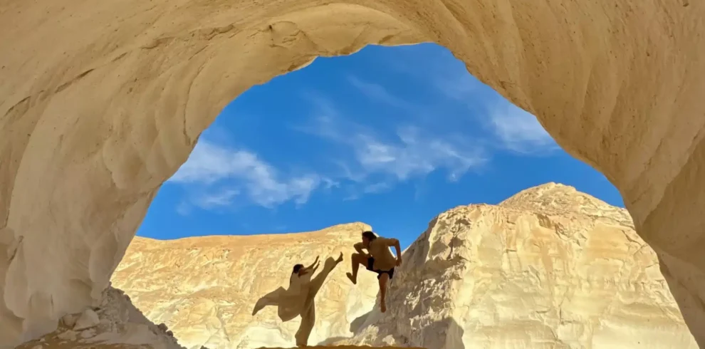
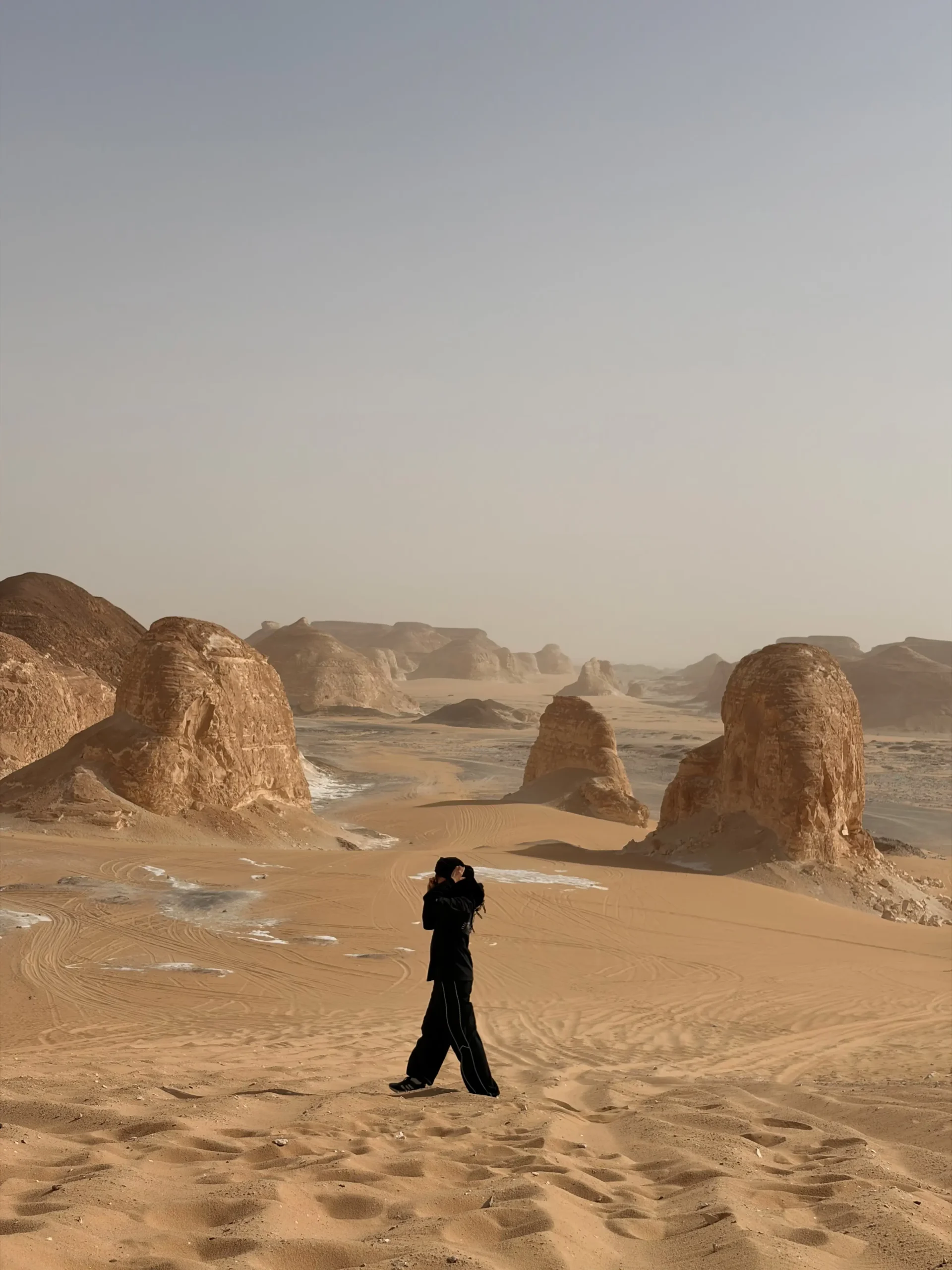
Agabat Valley is one of the most dramatic landscape zones on the route between Bahariya Oasis and Egypt's White Desert. Pale cliffs and isolated rock masses rise above soft golden sand, while dunes enter broad corridors that once made passage difficult. Most travelers see Agabat as part of a guided 4×4 safari that also includes the Black Desert, Crystal Mountain, and a White Desert camp.
This Agabat Valley Egypt travel guide explains where the valley is, how its landscape developed, how it fits into two- and three-day routes, whether you can camp there, and what to ask before booking. It also separates reliable evidence from repeated claims about the area being an ancient seabed, a dried river, or a place called the “Valley of Wonders.”
Direct answer: Agabat Valley—also written Aqabat, El Agabat, or Al Aqabat—is a remote system of pale sedimentary cliffs, sandy corridors, dunes, and eroded rock remnants in Egypt’s Western Desert. The wider rocks record ancient marine deposition, while later water flow, weathering, wind erosion, and sand movement helped create the modern valley. Visit with an official guide, a suitable 4×4, advance permits, and a route that follows current protected-area rules.
Agabat Valley quick facts
- Location: Western Desert on the Bahariya–Farafra–White Desert route.
- Landscape: pale cliffs, golden sand, dunes and broad off-road corridors.
- Access: usually from Bahariya Oasis by locally operated 4×4.
- Typical duration from Cairo: 2 days / 1 night for a compact circuit or 3 days / 2 nights for a slower route.
- Camping: only in locations allowed by the current protected-area route and permit conditions.
- Guide and permits: arrange in advance through an authorized operator or official guide.
Where is Agabat Valley?
Agabat Valley lies in Egypt's Western Desert within the route network linking Bahariya Oasis, Farafra, and the White Desert. It is commonly approached from Bahariya after a Cairo or Giza road transfer and a change to a locally operated 4×4.
The official Experience Egypt portal presents Aqabat Valley as a Farafra-area desert excursion and describes its golden sand, dunes, white cliffs, occasional shells, and ancient drainage setting. Tour operators approaching from Bahariya normally place it after the Black Desert, El Heiz, and Crystal Mountain, then continue toward the White Desert.
That does not give Agabat one ticket office or universally agreed entrance. “Agabat Valley” can refer to a broad landscape zone, a panoramic viewpoint, a dune corridor, or several connected off-road passages. The exact stop depends on:
- The operator's approved route
- Current permit instructions
- Sand conditions
- Vehicle capability
- Daylight
- Weather and visibility
- Protected-area zoning
- The chosen two- or three-day itinerary
Online map pins can point to different viewpoints. Use them to understand the general region, not as independent navigation instructions.
For the complete northern approach, read how to get to Bahariya Oasis from Cairo and how to get to the White Desert from Cairo.
Agabat, Aqabat, Al Agabat, or El Aqabat?
All four spellings can refer to the same general destination:
- Agabat Valley
- Aqabat Valley
- Al Aqabat
- El Agabat
- Valley of Agabat
Arabic names can be transliterated into Latin letters in several ways. The consonant represented by “q” may be heard or written differently in local and international usage, while the Arabic article may appear as al- or el-.
For SEO and traveler clarity, this guide uses Agabat Valley as the main name and includes Aqabat Valley as an accepted variant.
Does Agabat mean “Valley of Wonders”?
Several tourism pages translate the name as “wonders” or “beautiful valley.” A more literal connection is to the Arabic word for obstacles, difficult passages, or impediments. The name makes sense for a landscape where cliffs, sand, dunes, and narrow routes once complicated travel.
“Valley of Wonders” can be treated as a promotional nickname, not a reliable literal translation. The physical landscape is impressive without changing the meaning of its name.
What does Agabat Valley look like?
The visual character comes from contrast:
- White, cream, and pale-gray cliffs
- Warm yellow and golden sand
- Rounded hills and isolated rock masses
- Narrow sandy passages
- Broad bowls and corridors
- Dunes spilling against rock walls
- Darker weathered fragments on pale surfaces
- Long shadows that reveal relief at low sun
Unlike the classic White Desert, Agabat is not dominated by small mushroom-shaped sculptures scattered across a flat white floor. Its scale feels broader and more enclosed. Cliffs and large residual forms define corridors, while sand fills the low ground.
Unlike the Black Desert, Agabat is not characterized by dark basaltic caps and sheets of black gravel. The visual transition between the two is one reason the combined route is so effective.
Use the Black Desert Egypt travel guide to compare the major landscape zones before choosing a route.
Was Agabat Valley once under the sea?
The answer requires separating the age of the rock from the age of the valley.
Peer-reviewed research on the Bahariya–Farafra corridor describes the Late Cretaceous Khoman Chalk Formation as snow-white chalk and chalky limestone deposited in an open-marine, outer-shelf environment. Shells and other marine fossils in regional carbonate rocks reflect that ancient sea.
That means some of the pale material visible in the broader White Desert region began as marine sediment. It does not mean today's valley floor is simply a preserved seabed that dried yesterday. After deposition:
- Sediment was buried and turned into rock.
- Sea level and regional tectonics changed.
- The rocks were uplifted or exposed.
- Fractures, dissolution, runoff, and weathering attacked the succession.
- Wind and moving sand reshaped exposed surfaces.
- Dunes accumulated in the low corridors.
The correct statement is:
Agabat's regional bedrock includes sedimentary material with an ancient marine origin, while the modern valley and dunes formed through much later erosion and landscape development.
Avoid assigning every white cliff to the Khoman Chalk without a geological map at the exact stop. Several rock units occur across the Bahariya–Farafra corridor.
Is Agabat an ancient riverbed?
Egypt's official tourism portal describes Aqabat as the dried-up site of an ancient riverbed and advises visitors to look for occasional shells. This is a useful official summary, but it should not be turned into a single-process explanation for every cliff and dune.
A valley or drainage corridor can cut across rocks that are much older than the watercourse. In Agabat, the geological sequence may include:
- Ancient marine sedimentary rock
- Later fractures and weathering surfaces
- Channels or low areas affected by running water during wetter periods
- Sediment moved by episodic runoff
- Wind-eroded cliffs and rock faces
- Dunes and sand sheets formed under arid conditions
Research on the White Desert shows that wind is now a leading surface-shaping agent, while rare intense rainfall, water flow, and dissolution can still modify less resistant rock. The landscape is therefore neither “only river-made” nor “only wind-carved.”
Why the sea and river explanations do not conflict
They describe different moments:
- Marine deposition: formed part of the original sedimentary rock.
- Later drainage and erosion: cut or modified the exposed landscape.
- Modern arid processes: continue moving sand and weathering rock.
One place can record all three.
Why are there shells in Agabat?
The official Experience Egypt page mentions occasional seashells. Marine fossils are consistent with the regional history of chalk and limestone deposited in ancient seas.
However, a visitor should avoid three mistakes:
- Calling every shell a modern beach shell
- Assigning an exact species or age from a photograph
- Removing it as a souvenir
A fossil's scientific value depends on its rock unit, exact location, orientation, and relationship to surrounding sediment. A loose-looking shell may be weathering from bedrock nearby.
Do not dig, break a cliff, or collect fossils. The White Desert management plan identifies fossil and prehistoric-tool collection as a protected-area issue and treats removal of geological and archaeological resources as a violation.
How was Agabat Valley formed?
No single event produced the entire landscape. A practical geological model has five stages.
Stage 1: Sediment accumulated
During Late Cretaceous and later periods, sediment accumulated in changing marine and continental settings across the central Western Desert. In the broader Farafra region, chalk and chalky limestone record marine conditions.
Stage 2: Rock layers were exposed and fractured
Tectonic movement, changes in sea level, uplift, and erosion exposed different parts of the sedimentary succession. Joints and fractures gave water and weathering access to the rock.
Stage 3: Water modified the landscape
During wetter climatic phases, runoff and drainage followed low areas and weaknesses. Water could remove sediment, widen channels, undercut slopes, and dissolve carbonate material.
Stage 4: Aridity increased
As conditions became drier, vegetation and sustained surface flow declined. Older water-shaped landforms remained, while sediment dried and became available for wind transport.
Stage 5: Wind and sand reworked the exposed forms
Wind removed finer particles, carried sand, abraded exposed rock, and built dunes. Rock layers with different resistance weathered unevenly, leaving cliffs, isolated hills, and residual forms.
The 2023 Acta Carsologica study of the White Desert emphasizes that surface rock is co-shaped by several processes. Wind is dominant in many modern exposed settings, while rare rainfall and dissolution still affect less resistant rock.
What are the white cliffs made of?
The broader White Desert region contains chalk, chalky limestone, limestone, shale, chert bands, and other sedimentary materials. The 2016 geological heritage study describes the Khoman Chalk in the corridor between Bahariya and Farafra as distinctive snow-white chalk and chalky limestone, locally with chert and shale.
Chalk is a fine-grained carbonate rock largely composed of microscopic calcium-carbonate remains. It can be:
- Bright white when clean and freshly exposed
- Cream or beige when dusty
- Gray where weathered or shaded
- Harder where cemented
- Softer and more friable in other layers
This variation affects landform shape. Resistant layers remain as ledges or caps; softer beds retreat into slopes and hollows.
Do not assume that all pale cliffs are soft enough to crumble or strong enough to climb. Appearance alone is not a stability test.
Why are the dunes golden?
The valley floor and corridors contain sand from sources and processes different from the pale carbonate cliffs. Quartz-rich desert sand commonly appears yellow, gold, beige, or orange because of grain coatings, mineral mixtures, lighting, and weathering.
Wind moves the available sand into:
- Ridges
- Slip faces
- Sand sheets
- Small crescents
- Dune tongues against cliffs
- Corridors shaped by local wind flow
Where sand meets white rock, the color contrast becomes especially strong. Low-angle sunlight warms the dune color and casts shadows that make cliff relief more visible.
The dunes are active landforms. Their exact height, edge, and driving line can change, which is one reason local route knowledge matters.
Is Agabat part of the White Desert?
Agabat is commonly included in the wider White Desert journey and is presented by official tourism sources as a Farafra desert attraction. Operationally, it acts as a transition between Crystal Mountain and the iconic White Desert formation areas on many Bahariya-based routes.
Travelers use “White Desert” in three ways:
- The protected area or national park
- The wider regional safari circuit
- The most famous central zone of chalk mushrooms and towers
Agabat belongs to the broader journey and protected landscape, but its cliff-and-dune scenery is distinct from the classic chalk-sculpture field.
Read the ultimate guide to the White Desert in Egypt for the whole region.
Agabat Valley versus the classic White Desert
Both deserve time. Treating Agabat as a quick photo on the way to the “real” White Desert misses the scale and geological transition.
Agabat Valley versus Crystal Mountain
Crystal Mountain is a compact exposed karst and cave feature known for calcite crystals, breccia, and an arch. Agabat is a much broader landscape of cliffs, sand, dunes, and passages.
Read the Crystal Mountain Egypt travel guide before the trip so the two places do not merge into one generic “White Desert” memory.
Agabat Valley versus the Black Desert
The Black Desert is defined by dark hills, basaltic caps or intrusions, ferruginous sedimentary material, and black gravel spread across a paler floor. Agabat is brighter, sandier, and dominated visually by pale cliffs and golden corridors.
A north-to-south itinerary can therefore show:
- The inhabited Bahariya depression
- Dark capped hills of the Black Desert
- El Heiz and transitional desert
- Crystal Mountain's calcite-rich karst
- Agabat's white cliffs and golden dunes
- The White Desert's chalk sculptures
This sequence is one of the strongest reasons to choose an overland safari rather than visiting one isolated viewpoint.
Read the Black Desert Egypt travel guide for the first geological contrast.
What will you do in Agabat Valley?
The actual activities depend on permission, route conditions, group ability, and the operator's program. A visit may include:
- Stopping at a high panoramic viewpoint
- Driving through approved sandy passages
- Short walks on stable ground
- Photographing white cliffs and golden dunes
- Watching sand patterns and wind ripples
- A tea or rest stop
- Sandboarding on a suitable permitted slope
- Continuing toward Moon Cave or the White Desert
- Passing the area near sunset
Do not assume all activities are guaranteed. A good guide may skip a dune because of wind, softness, vehicle traffic, wildlife sensitivity, or time.
Is sandboarding available?
The 2016 geological heritage paper lists sandboarding among activities offered within the wider White Desert protectorate. Some safari routes use suitable dunes around the Agabat sector.
Before assuming it is included, ask:
- Is a board supplied?
- Is the selected slope currently approved?
- Is the activity suitable for children?
- Will the group walk back up the dune?
- Is footwear required?
- What happens if wind or sand conditions are poor?
Never sandboard toward vehicles, rocks, plants, drop-offs, or another group. Avoid waxes or materials that can contaminate the sand.
Can you camp in Agabat Valley?
Possibly, but not anywhere you choose.
The official White Desert management plan divides the protected area into zones with different rules. It states that:
- Some strict zones allow no public vehicle access or camping.
- Some wilderness zones restrict vehicle access and may permit camping only for trekkers or camel users under defined conditions.
- Recreational zones allow vehicles on designated tracks and camping only in designated sites or zones.
This means “wild camping” is not a general right. A current permit, guide, and operator must determine the legal and environmentally appropriate camp location.
Many two-day itineraries visit Agabat and then continue to a designated White Desert camping area. That can be better than camping inside the exact valley because it protects sensitive corridors and places the group closer to morning formations.
When requesting a quote, ask the operator to state whether the night is:
- In Agabat Valley
- Near Agabat
- Inside another approved White Desert zone
- In a fixed or semi-fixed camp
- In a temporary mobile camp
The distinction affects both expectations and environmental impact.
What is camping like?
A basic mobile camp may include:
- Sleeping tent or wind shelter
- Mattress
- Sleeping bag or blankets
- Dinner and breakfast
- Drinking water
- Simple seating
- Camp lighting
- Basic toilet arrangement
- Local desert team
Services vary. “Camping included” does not automatically mean a private tent, standing-height shelter, fixed bathroom, hot shower, or hotel-style bedding.
Ask the following before paying:
- Is the tent private?
- Are mattresses, sleeping bags, and blankets supplied?
- How is the toilet handled?
- Is there a privacy shelter?
- What meals and drinks are included?
- Can dietary restrictions be accommodated?
- How is waste removed?
- What happens in high wind?
- Is a hotel night in Bahariya part of the program?
- Where is the camp relative to Agabat?
The White Desert camping guide answers these questions in detail.
Leave-no-trace camping in a protected desert
The White Desert management plan calls for inorganic waste to be carried outside the protected area and for vehicle routes and visitor impacts to be controlled.
Responsible camp behavior includes:
- Pack out all plastic, metal, glass, batteries, and wipes.
- Use the operator's toilet system.
- Never bury wet wipes or sanitary products.
- Keep food scraps controlled.
- Do not burn plastic or foil.
- Use existing approved fire practices only.
- Avoid collecting dead plants for fuel.
- Keep lights and music low.
- Do not move rocks to build furniture or windbreaks.
- Leave no charcoal scar.
- Do not drive extra circles around camp.
“Biodegradable” does not mean harmless in a hyper-arid environment. Organic material can remain visible for a long time and alter wildlife behavior.
Can you visit Agabat without camping?
Yes. Agabat can be included as a daytime stop within a longer route, but most Cairo-based programs are more comfortable with at least one night because road and desert driving times are substantial.
Options include:
- A compact two-day/one-night circuit
- A three-day/two-night desert route
- A Bahariya hotel night plus one desert camp
- A route continuing toward Farafra
- A customized photography or geology itinerary
A same-day Cairo return forces long vehicle hours and reduces time at the landscape stops. It should not be presented as equivalent to a two-day expedition.
Compare the 2-day White Desert itinerary with the 2-day vs 3-day White Desert guide.
The usual route from Cairo
A typical operating sequence is:
Cairo or Giza to Bahariya
The group leaves early and travels by road to Bahariya Oasis. This is a transfer stage, not yet the deep-desert safari.
Bahariya preparation
Travelers meet the local desert team, eat or prepare according to the itinerary, and move into a suitable 4×4.
Black Desert and El Heiz
The route crosses dark hills and may stop at El Heiz for lunch, rest, or a spring visit depending on the program.
Crystal Mountain
The group visits the exposed calcite-rich karst feature before entering broader pale-cliff landscapes.
Agabat Valley
The vehicle reaches one or more viewpoints and approved corridors. Time may include walking, photography, or sandboarding.
White Desert camp
The route continues to the approved overnight zone. Dinner, stargazing, and sleep follow.
Morning formations and return
After breakfast and sunrise, the group visits additional formations, returns to Bahariya, and transfers to Cairo or Giza.
The route can be reversed or modified. Weather, permits, maintenance, and daylight take priority over a blog sequence.
Which Elzaghandi Travel tours include Agabat?
Agabat appears within active Elzaghandi Travel desert routes:
- 2 Days / 1 Night White Desert Adventure — a compact circuit including Bahariya, the Black Desert, Crystal Mountain, Agabat, and a White Desert camp.
- 3 Days / 2 Nights Bahariya Oasis & White Desert Adventure — adds inhabited-oasis context before the desert circuit.
- 3 Days / 2 Nights White Desert Adventure — allows a deeper route and a less compressed pace.
- 3 Days / 2 Nights White Desert & Djara Cave Adventure — connects the White Desert route with the more remote Djara Cave expedition, subject to current access and permissions.
Confirm the live itinerary for your dates. An article describes possibilities; it is not a booking contract.
For a private route emphasizing Agabat photography or geology, use the customize your trip form.
Is Moon Cave in Agabat?
“Moon Cave” is a route name used in some desert itineraries for a small cave or sheltered geological feature in the broader Agabat/White Desert journey. Names and exact stopping points can vary between local guides.
Before booking, ask:
- Is Moon Cave included?
- Is it an open shelter or an enclosed cavity?
- Is entry currently permitted?
- How long is the walk?
- Is the terrain stable?
- Is the name used for the same site shown in the itinerary photographs?
Do not confuse Moon Cave with Djara Cave. Djara is a major remote cavern with speleothems, prehistoric imagery, and different logistics.
Agabat Valley and Djara Cave
Agabat is a normal component of many White Desert circuits. Djara requires a longer remote route and should be planned as a separate expedition component.
If Djara Cave is a priority, use the published 3 Days / 2 Nights White Desert & Djara Cave Adventure as the current commercial reference and confirm access for your dates.
Do you need a 4×4?
Yes for the off-road Agabat and connected White Desert route.
A desert-ready 4×4 is needed for:
- Soft sand
- Dune approaches
- Uneven tracks
- Long remote distances
- Carrying water and camp equipment
- Tire and recovery requirements
- Route changes caused by sand movement
Vehicle type alone is not enough. The driver needs local experience, and the team needs suitable tires, a spare, tools, recovery equipment, water, fuel planning, and a communications procedure.
Do not attempt to follow another vehicle or a downloaded track in a rental car. If the lead vehicle disappears in dust or darkness, the map file cannot recover a buried wheel or arrange a permit.
Permits and official guide requirements
Requirements can change. The UK FCDO guidance reviewed on 7 September 2026 says tourists entering Bahariya, Farafra, the White Desert, and the Black Desert must apply for permits in advance and use an official guide. It also notes limited phone reception and poor medical facilities.
Experience Egypt similarly advises visitors to confirm permits and regulations with a travel agency or authorized guide.
Before departure:
- Send required traveler details through the operator's legitimate process.
- Confirm who arranges the permit.
- Carry the required identification.
- Check current advice from your own government.
- Confirm that travel insurance covers desert activities.
- Ask about emergency communications.
- Follow checkpoint instructions.
- Do not substitute the separately warned Bahariya–Siwa road for the normal southbound route.
The White Desert safety guide explains risk, permits, health planning, communications, and vehicle questions.
Is Agabat Valley safe?
It can be visited responsibly with the right operator, guide, vehicle, permit, supplies, and weather plan. It is not a controlled urban attraction.
Key risks include:
- Vehicle becoming stuck
- Tire damage
- Navigation error
- Heat and dehydration
- Cold desert night
- Strong wind or blowing sand
- Loose cliff material
- Falls on dune faces
- Limited phone reception
- Distance from advanced medical care
- Unplanned separation from the group
The White Desert management plan identifies visitor safety and emergency-response planning as management priorities. Travelers should still carry personal medication and disclose relevant medical limitations before the trip.
Walking and hiking
Short walks are usually possible where the guide confirms stable ground and permitted access. Long independent hikes are not appropriate without specific planning.
Walking conditions may include:
- Soft sand
- Gravel
- Wind ripples
- Steep dune slopes
- Loose chalk fragments
- Crusted surfaces
- Hidden holes beside rocks
- Strong sun with little shade
Stay within sight and voice range of the guide. A broad corridor can hide a person quickly behind a dune or rock mass.
For a dedicated trek, ask about:
- Route distance and elevation
- Guide-to-guest ratio
- Water carried per person
- Vehicle support
- Emergency evacuation
- Camp zoning
- Footwear
- Heat limits
- Camel support, if offered
Sandboarding safety
If sandboarding is included:
- Use the guide-selected slope.
- Check the runout for rocks and vehicles.
- Wait until the previous rider clears the path.
- Sit rather than stand if inexperienced.
- Remove straps that can twist a knee.
- Keep phones and cameras secured.
- Stop if wind reduces visibility.
- Do not board fragile crust or vegetated ground.
Walking back up a dune can be physically demanding. Travelers with heart, knee, ankle, or heat-related concerns should skip the activity without pressure.
Best time to visit Agabat Valley
Cooler months are generally the most comfortable for exposed desert travel. The best dates depend on daytime heat, night temperature, wind, school holidays, and the type of camp.
Cooler season
Daytime walking is easier, but nights can be cold. Warm sleep gear matters more than many travelers expect.
Shoulder periods
Conditions may be comfortable, with fewer peak-season groups. Heat can rise quickly, so current forecasts remain important.
Summer
High temperatures increase dehydration and heat-illness risk. Operators may adjust departure times, activities, and outdoor exposure.
Use the best time to visit the White Desert guide for seasonal decision-making.
Best time of day for photography
Early morning
Low sun reveals dune ripples and separates pale ridges from the background. Air can be clearer, but route schedules may place the group elsewhere at sunrise.
Midday
White cliffs become extremely bright and shadows contract. Golden sand and pale rock show strong color contrast, but glare and heat increase.
Late afternoon
Long shadows reveal depth, cliff faces turn warmer, and dunes become more sculptural. This is often the most dramatic light if the approved itinerary reaches a safe viewpoint in time.
Blue hour and night
If camping in an approved nearby zone, cliffs and dunes can become silhouettes. Never walk away from camp in darkness without the guide.
The White Desert stargazing and photography guide covers tripods, batteries, moonlight, dust, and night safety.
Photography composition ideas
Try a complete visual sequence:
- Establishing frame: a wide view of cliffs and sand.
- Scale frame: a person or parked vehicle at a safe, approved position.
- Layer frame: foreground ripples, a mid-ground rock mass, and distant cliffs.
- Texture frame: wind patterns without footprints.
- Route frame: a single approved track showing the valley's scale.
- Transition frame: dark Black Desert material or bright White Desert chalk before and after Agabat.
Do not drive or walk across an untouched surface just to create a composition. A photograph of a pristine dune is valuable because the dune is pristine.
What should you wear?
Pack for driving, walking, camp, and temperature change:
- Closed shoes with grip
- Breathable long trousers
- Light long-sleeved top
- Sun hat
- Sunglasses
- High-SPF sunscreen
- Scarf or buff
- Warm fleece or jacket
- Wind-resistant layer
- Warm socks for camp
Avoid flip-flops on slopes and around camp. Fine sand enters shoes easily, so gaiters may help on a walking-focused itinerary.
What should you pack?
Useful personal items include:
- Refillable water bottle
- Personal medication
- Small first-aid essentials
- Power bank
- Headlamp with spare batteries
- Camera dust protection
- Warm sleep layer
- Lip balm
- Hand sanitizer
- Toilet paper supplied or confirmed with the operator
- Waste bags
- Offline itinerary and emergency contact
- Required identification
Do not bring a geological hammer, fossil bag, drone without authorization, or single-use items you do not intend to carry out.
Use the complete White Desert packing list before departure.
Can families visit?
Families can visit with a properly planned private or suitable shared route. Consider:
- Child age and car-seat needs
- Total road and 4×4 time
- Motion sickness
- Heat tolerance
- Food preferences
- Toilet arrangements
- Cold night temperatures
- Close supervision near cliffs and dunes
- Medication
- Ability to sleep in a tent
Ask for an honest schedule rather than a marketing summary. A child who enjoys a short dune stop may still struggle with a long return drive.
Accessibility and mobility
Agabat is a natural off-road landscape, not a paved accessible attraction. The useful question is not simply “Is it wheelchair accessible?” but:
- How close can the approved vehicle stop to the viewpoint?
- Is the surface firm or soft?
- Is a step needed to enter the 4×4?
- Can the traveler remain seated and still see the landscape?
- Can mobility equipment be carried securely?
- Is assistance available?
- How will toilet needs be managed?
A private itinerary can sometimes be adapted, but the operator must assess the actual route and vehicle.
Wildlife and plants
The White Desert protected area supports desert wildlife and fragile habitats. The management plan identifies the area as important for species including slender-horned and Dorcas gazelles, but sightings are never guaranteed.
Responsible behavior:
- Observe from a distance.
- Do not feed foxes, birds, or other animals.
- Store food securely.
- Do not leave scraps.
- Avoid spotlighting wildlife for long periods.
- Do not remove plants for firewood.
- Keep noise low at night.
- Follow seasonal route restrictions.
Feeding changes animal behavior and can make wildlife dependent on camps.
Common myths and corrections
Myth 1: Agabat means “Valley of Wonders”
Correction: The name is more closely related to obstacles or difficult passages. “Valley of Wonders” is a promotional nickname.
Myth 2: The valley is only an ancient seabed
Correction: Regional marine sediment formed some of the rock, but later uplift, water erosion, wind, weathering, and dunes created the modern landscape.
Myth 3: The valley was made only by a river
Correction: Official tourism material describes an ancient riverbed, but several geological processes acted at different times.
Myth 4: Wind created the marine fossils
Correction: Fossils originated in sedimentary environments. Wind later exposed and weathered the rock.
Myth 5: You can camp anywhere because it is empty
Correction: Protected-area zones have different rules, and camping may be limited to designated locations.
Myth 6: Any SUV can cross Agabat
Correction: A capable vehicle, experienced local driver, recovery equipment, permits, and route knowledge are required.
Myth 7: Sandboarding is always included
Correction: It depends on the itinerary, equipment, permitted slope, weather, and sand conditions.
Myth 8: Agabat and the White Desert are the same stop
Correction: Agabat is a distinct cliff-and-dune landscape within the broader White Desert circuit.
Myth 9: Collecting one shell does no harm
Correction: Removing fossils destroys geological context and contributes to cumulative protected-area damage.
Myth 10: Phone GPS makes a guide unnecessary
Correction: GPS cannot arrange permits, evaluate dunes, recover a vehicle, or replace local emergency planning.
How to choose an Agabat Valley tour
Ask for written answers to:
- Is Agabat specifically named in the current itinerary?
- Which viewpoints or activities are planned?
- Is sandboarding included?
- Where is the overnight camp?
- Is camping in a designated zone?
- Is the trip private or shared?
- What vehicle is used after Bahariya?
- Who arranges permits?
- What meals and water are included?
- What sleeping equipment is supplied?
- What toilet arrangement is used?
- What is the emergency communication plan?
- What happens if wind or access changes?
- Is hotel accommodation included?
- What is the cancellation policy?
Comparing only the headline price can be misleading. Group size, vehicle allocation, pickup, permit handling, camp equipment, food, and duration affect the quote.
Two days or three days?
Choose two days if:
- Your schedule is limited.
- You accept a compact pace.
- One desert night is enough.
- Your priorities are the main route contrasts.
Choose three days if:
- You want more time in Bahariya.
- Photography is important.
- You prefer less compressed driving.
- You want two nights or more camp time.
- You may add Djara Cave or deeper route sections.
Three days do not automatically mean every additional destination is included. Read the exact day-by-day program.
A realistic two-day outline
Day 1
- Cairo or Giza pickup
- Bahariya transfer
- Lunch and 4×4 change
- Black Desert
- El Heiz according to itinerary
- Crystal Mountain
- Agabat Valley
- Approved White Desert camp
Day 2
- Sunrise and breakfast
- White Desert formations
- Return to Bahariya
- Cairo or Giza transfer
This outline is a planning model. The active tour page controls the booked service.
A realistic three-day outline
Day 1
- Cairo to Bahariya
- Oasis attractions or first desert sector
- Hotel or camp according to the selected program
Day 2
- Black Desert
- El Heiz
- Crystal Mountain
- Agabat Valley
- White Desert camp
Day 3
- Morning formations
- Additional approved stops
- Return through Bahariya to Cairo
A Djara Cave version requires a different route allocation and should not be added casually to this outline.
Related Western Desert guides: See Agabat in context with the Crystal Mountain guide, the White Desert travel guide, and the 3-day White Desert and Djara itinerary.
Frequently asked questions
What is Agabat Valley?
Agabat is a remote Western Desert landscape of pale sedimentary cliffs, golden sand, dunes and broad off-road corridors on the wider Bahariya–Farafra–White Desert route.
Where is Agabat Valley in Egypt?
It lies in Egypt’s Western Desert and is commonly visited after Crystal Mountain and before the classic White Desert formation zones on Bahariya-based itineraries.
Is it called Agabat or Aqabat?
Both are common transliterations. Al Aqabat and El Agabat also refer to the same general destination.
Is Agabat part of the White Desert?
It is part of the wider White Desert safari circuit and protected landscape, but its cliff-and-dune scenery is visually distinct from the classic chalk formations.
Was Agabat once under the sea?
Parts of the regional sedimentary rock formed in ancient marine environments. The modern valley developed much later through exposure, water erosion, weathering, wind and dune movement.
Why are there shells in Agabat?
Marine fossils occur in regional carbonate rocks deposited in ancient seas. Visitors should leave shells, fossils and rocks in place.
How do you get to Agabat Valley from Cairo?
Most travelers go by road from Cairo or Giza to Bahariya Oasis, then change to a locally operated 4×4 for the off-road desert circuit.
Do you need a 4×4?
Yes for the Agabat and connected White Desert off-road sections. A capable vehicle and an experienced local desert driver are essential.
Do you need a guide and permit?
Yes. Current regional guidance requires advance permits and an official guide for tourists entering Bahariya, Farafra, the White Desert and Black Desert areas.
Can you camp in Agabat Valley?
Only where the current route and protected-area rules allow it. Many itineraries visit Agabat and then continue to an approved White Desert camping zone.
Can you visit Agabat without camping?
Yes, but from Cairo a two-day route with one overnight stay is much more practical than trying to return the same day.
Is sandboarding available?
Sometimes. It depends on the itinerary, board availability, permitted slope, weather and current sand conditions.
Is Agabat suitable for children?
It can be suitable for families on a properly planned route, but parents should consider road time, 4×4 travel, heat, cold nights, food and toilet arrangements.
What is the best time to visit?
Cooler months are generally more comfortable for desert travel. Check current weather and wind conditions before departure.
Is two days or three days better?
Two days is the compact practical option from Cairo. Three days gives more time for photography, a slower pace and additional desert stops.
Trusted sources and further reading
This article uses official visitor information, protected-area management documents, and regional peer-reviewed geology:
- Experience Egypt: Desert Excursions — official description of Aqabat's golden sand, dunes, white cliffs, shells, ancient drainage setting, and permit advice.
- Egyptian Environmental Affairs Agency: White Desert Protected Area management plan — official protection, zoning, camping, vehicle-track, waste, fossil, visitor-safety, and management framework.
- Geological heritage of the Bahariya and Farafra oases — regional stratigraphy, Khoman Chalk, marine setting, landforms, geotourism, and conservation.
- Karst Rock Relief of Qara and White Desert — explains the combined effects of wind, rare rainfall, dissolution, and earlier karst processes.
- Geoheritage meaning of past humidity in the central Western Desert — documents evidence of wetter Quaternary environments across Bahariya and Farafra.
- Current UK regional travel advice for Egypt — current permit, official-guide, phone-reception, medical-facility, and regional-risk guidance; recheck before travel.
Plan an Agabat Valley and White Desert trip
Agabat is best experienced as part of a connected route rather than an isolated map pin. The full sequence shows how one desert corridor changes from Bahariya's oasis depression to the Black Desert, Crystal Mountain, Agabat's pale cliffs and dunes, and the White Desert's chalk sculptures.
For a personalized quote, send:
- Travel dates
- Number and ages of travelers
- Cairo or Giza pickup point
- Two-day or three-day preference
- Private or shared-trip preference, if available
- Camping and toilet expectations
- Dietary requirements
- Medical or mobility considerations
- Interest in sandboarding, geology, photography, Moon Cave, or Djara Cave
Request an Agabat Valley and White Desert itinerary on WhatsApp. Route, camp location, permits, availability, inclusions, and access must be confirmed in writing for your dates.

Things to Do in Cairo Egypt: 15 Best Attractions & Experiences

Cairo Egypt Travel Guide: Itinerary, Attractions & Practical Tips
Dahshur Pyramids Guide: Bent Pyramid, Red Pyramid & Visiting Tips
Recent Posts

Things to Do in Cairo Egypt: 15 Best Attractions & Experiences

Cairo Egypt Travel Guide: Itinerary, Attractions & Practical Tips
Dahshur Pyramids Guide: Bent Pyramid, Red Pyramid & Visiting Tips